Thursday 31 March 2016

Andaman Islands

ABOUT : Andaman Islands
The Andaman Islands are an dry land in India’s Bay of Bengal.Roughly 300 islands are known for their palm-lined, white-sand beaches, mangroves and rainforested parts. Covered with coral reefs that support marine life including sharks and rays, there destinations for scuba diving and snorkeling. There also popular for water skiing, windsurfing and fishing. Oceanside camping and hiking is possible on some islands.
Andaman & Nicobar Islands are a group of over  570 Islands, islets and rocks(36 of which are populated) in the Bay of Bengal, South-East of the Indian mainland.  The Andaman & Nicobar Islands is  near to Myanmar, Indonesia and Thailand than the Indian  mainland.

Andaman & Nicobar Islands extends over a length of more than 750 kms from North to South. Some of large Islands are Middle Andaman, North Andaman, South Andaman, Baratang and Little Andaman islands.The northern most point is Landfall Island and the southern most, Indira Point.

The Nicobar group of Islands is out of bounds for Tourism activities.And only the Andaman group of Islands  are famous for Tourism. Because of the majority of the people are living in these Islands are Tribals.

Fact File

Location  :  Bay of Bengal 92o to 94o East Longitude 6o to 14o North Latitude
Total  Area  : 8,249 sq.km. (Andaman-6408 sq.kms., Nicobar-1841 sq.km.)
Total Islands : 572
Inhabited Islands : 36
Capital  : Port Blair
Districts  :  3 (Andamans, Nicobars & North and Middle Andaman)
Altitude  :  Varies from Sea level to 732 metres Highest Point
Andaman Islands :  Saddle Peak (North Andaman Island : 732 Metres)
Nicobar Islands   : Mount Thullier (Great Nicobar Island : 642 Metres)
Forest Cover :    92 %
Climate  : Tropical and Humid. Humidity ranges between 70% and 90% with a gentle breeze blowing at all times. The weather is generally pleasant   with a minimum temperature of 23°C and maximum 30°C.
Ideal Tourist Season : Every year from October to May
For Monsoon Holidays : Every year from June to September
Rainfall  :   3000 mms (May to mid-September and November to January)

Relative Humidity :  75% to 90%

The major languages in Andaman & Nicobar Islands are Bengali, Hindi, Malayalam, English, Tamil, Nicobarese and Telugu.


visiting to the Andaman And Nicobar Islands is a memorable lifetime experience.

KASHMIR TOURIST PLACE

TOURIST DESTINATIONS IN J&k

Information About J&K:
Mughal emperor Jahangir discovered the striking beauty of the Kashmir valley in the 17th century, and said, “Gar firdaus, ruhe zamin ast, hamin asto, hamin asto, hamin asto.” i.e., “if there is a paradise anywhere on the earth, it is here.” Since then this Paradise on Earth located in North India has been receiving millions of tourists locally and from around the globe, annually.
Attractions of the state include Srinagar, Pahalgam, Gulmarg, Patnitop, Zanskar, Leh and Ladakh and Jammu City.
Houseboats are the floating hotels of this awe-inspiring holiday destination. Carved from sturdy yet light oak and walnut wood, these accommodations offers a unique experience. Budget hotels & Luxury suites for tourists available all round the year.

Jammu and kashmir is a state in northern India. It is located mostly in the Himalayan mountains, and shares a border with the states of Himachal Pradesh and Punjab to the south. Jammu and Kashmir has an international border with China in the north and east, and the Line of Control separates it from the Pakistan-controlled territories of Azad Kashmir and Gilgit-Baltistan in the west and northwest respectively. The state has special autonomy under Article 370 of the Constitution of India.

Area: 222,236 km²
Elevation: 327 m
Founded: October 26, 1947
Population: 12.55 million (2011)

Capitals: Jammu (Winter), Srinagar (Summer)

Things To Do:

The inclined meadows, craggy terrains, astounding mountains and arrogant hills offer a vantage point for adventure activities – trekking, rock climbing, camping, skiing, snow boarding and Paragliding. The gurgling streams, brooks, and rivers invite you to river rafting, water skiing, and fishing/angling. The lush valley offers a great opportunity to play golf in the summers, while the same valley during the winters turn into the ice skating grounds for the visitors.

LadakhLadakh is a region in the Indian Administered Jammu and Kashmir that currently extends from the Kuen Lun mountain range to the main Great Himalayas to the south, inhabited by people of Indo-Aryan and Tibetan descent.

Main Attraction: In this area is Bactarian Camels (Shaggy double hump Camel) around sand dunes, Deskit & Samstanling monasteries and Khardung la Pass ( the world highest motor able road.)
Best Time to visit: May to October

 Ladakh is home to some very beautiful lakes. As peak winter temperatures hover near – 35  degrees for days at a time, everything in Ladakh freezes. The Indus and Zanskar become broad highways of ice, and the great lakes, Pangong and Tso Morari, freeze to a depth of several meters.

Khilanmarg:
Jammu & Kashmir, India is a small valley about a 6-km walk from the Gulmarg bus stop and car park. The meadow, carpeted with flowers in the spring, is the site for Gulmarg’s winter ski runs and offers a fine view of the surrounding peaks and over the Kashmir Valley. It’s a 600-metre ascent from Gulmarg to Khilanmarg and during the early spring, as the snow melts, it can be a very muddy hour’s climb up the hill. The effort is rewarded, if it’s clear, with a sweeping view of the great Himalayas from Nanga Parbat to the twin 7,100-metre peaks of Nun and Kun to the southeast.


Amarnath Temple:

Amarnath cave is a Hindu shrine located in Jammu and Kashmir, India. The cave is located at an altitude of 3,888 m (12,756 ft), about 141 km (88 mi) from Srinagar, the capital of Jammu and Kashmir and reached through Pahalgam town. The shrine forms an important part of Hinduism,and is considered to be one of the holiest shrines in Hinduism.The cave is surrounded by snowy mountains. The cave itself is covered with snow most of the year except for a short period of time in summer when it is open for pilgrims. Thousands of Hindu devotees make an annual pilgrimage to the Amarnath cave on challenging mountainous terrain to see an ice stalagmite formed inside the cave.


Manali, Himachal Pradesh

About:Himachal Pradesh &Manali,
Himachal Pradesh, a northern Indian state in the Himalayas, is known for its trekking, climbing and skiing, and scenic mountain towns and resorts such as Dalhousie. Host to the Dalai Lama, Himachal Pradesh also has a strong Tibetan presence, reflected in its Buddhist temples and monasteries, cuisine heavy on noodles and dumplings, and vibrant Tibetan New Year celebrations.
Area: 55,673 km²
Founded: January 25, 1971
Elevation: 2,319 m
Capital: Shimla

Population: 6.856 million (2012)
MANALI:
Manali is a high-altitude Himalayan resort town in India’s northern Himachal Pradesh state. It has a reputation as a backpacking center and also honeymoon destination. Set on the Beas River, it’s a gateway for skiing in the Solang Valley and trekking in Parvati Valley. It's also a jumping-off point for paragliding, rafting and mountaineering in the Pir Panjal mountains, home to 4,000m-high Rohtang Pass.
Manali is a small town as of the 2011 census of India, its population was 8,096.In 2001, Manali had an official population of 6,265.
The climate in Manali is predominantly cold during winters, and moderately cool during summers. The temperatures range from 4 °C (39 °F) to 20 °C (68 °F) over the year. The average temperature during summer is between 04 °C (39 °F) and 15 °C (59 °F), and between −15 °C (5 °F) and 05 °C (41 °F) in the winter.

Elevation: 2,050 m

Population: 8,096 (2011)


                Vashisht Temple in Manali.

Sunday 6 March 2016

KANYAKUMARI TOURISM PLACES

ABOUT KANYAKUMARI:-

Kanyakumari is a coastal town in the state of Tamil Nadu on India's southern tip. Jutting into the Laccadive Sea, the town was known as Cape Comorin during British rule and is popular for watching sunrise and sunset over the ocean. It's also a noted pilgrimage site thanks to its Bagavathi Amman Temple, dedicated to a consort of Shiva, and its Our Lady of Ransom Church, a center of Indian Catholicism.

Area: 25.89 km²
Elevation: 30 m
Weather: 32°C, Wind E at 13 km/h, 54% Humidity

Population: 29,761 (2012)


Gandhi Memorial
 Vivekananda Rock Memorial

OOTY TOURISM PLACES

ABOUT OOTY:-

Udhagamandalam and abbreviated as Udhagai and Ooty is a town and municipality in the Indian state of Tamil Nadu. It is located 80 km north of Coimbatore and is the capital of the Nilgiris district.

Ooty is located in the Nilgiri hills. The name meaning blue mountains in Tamil name might have arisen from the blue smoky haze given off by the eucalyptus trees that cover the area or from the kurunji flower, which blooms every twelve years giving the slopes a bluish tinge.The beautiful mountains and green valleys led to the epithet Queen of Hill Stations.

Elevation: 2,240 m
Weather: 23°C, Wind E at 8 km/h, 55% Humidity
Getting there: 1 h 20 min flight. View flights
Population: 88,430 (2011)


Ooty Lake


Catherine Falls, also known as St. Catherine's Falls, is located in the area that surrounds Coonoor. This beautiful waterfall falls from an impressive 250 feet. It can clearly been seen from the top of Dolphin's Nose if seeing the entire waterfall as one total impression is what you are looking for. It is also possible to take a road to the top of the falls. This vantage point allows you to truly appreciate the awesome power that Mother Nature has contained within a waterfall as you look down the 250 feet to the pool of water and its surrounding landscape below. To reach here the top of the hills tourist should take a diversion at Aravenu on Kotagiri - Mettupalayam road

Ooty Catherine Falls


DARJEELING TOURISM PLSCES

About Darjeeling:-

Darjeeling is a Famous city in West Bengal state in India , in the Himalayan foothills. Once a summer resort for the British Raj elite, it is remains the terminus of the narrow-gauge Darjeeling Himalayan Railway, or “Toy Train,” completed in 1881. This place very famed for the distinctive black tea grown on plantations that dot its surrounding slopes. Its backdrop is Mt. Kanchenjunga, among the world’s highest peaks.

This is the land of the muscatel flavoured Darjeeling tea revered by connoisseurs across the globe. This is the land of the world heritage Darjeeling Himalayan Railway where the century old miniature steam engine still chugs uphill vying for space with the fast disappearing Land Rovers.

"Flowers are everywhere. The days are cold and the sun almost seems to play hide and seek with us".  Kabiguru Rabindranath Tagore.

It is certainly that Darjeeling in the post modern era comprises of six T’s -Tea, Teak, Tourism, Toy Train, Tiger Hill and Trekkers’ paradise And etc....

Elevation: 2,042 m
Area: 10.57 km²
Weather: 19°C, Wind S at 8 km/h, 60% Humidity
Getting there: 5 h 25 min flight, around ₹ 32,165
Local time: Sunday 2:31 PM
Population: 107,197 (2001) UNdata
Government body: Darjeeling Municipality


Thursday 3 March 2016

MAHARASHTRA TOURISM PLSCES

ABOUT MAHARASHTRA:-
Maharashtra state spanning west-central India, is best known for its fast-paced capital, Mumbai (formerly Bombay). This sprawling metropolis is the seat of the Bollywood film industry. It’s also famed for sites like the British Raj-era Gateway of India monument and the cave temples at nearby Elephanta Island. To the south is the rustic, beach-lined Konkan coast, and its temple town of Ganpatipule.
Maharashtra attracts many tourists from different states and foreigners too and is the most visited state by domestic tourists in country in 2010. Aurangabad is the tourism capital of Maharashtra.

Major urban centers include : Mumbai, Pune, Nashik, Aurangabad, Nanded and Nagpur.

Area:307,713 km²
Founded: May 1, 1960
Capital: Mumbai
Population: 114.2 million (2012)
Government body: Government of Maharashtra

LONAVALA:-

Lonavala is a hill station surrounded by green valleys in western India near Mumbai. The Karla Caves and the Bhaja Caves are ancient Buddhist shrines carved out of the rock. They feature massive pillars and intricate relief sculptures. South of the Bhaja Caves sits the imposing Lohagad Fort, with its 4 gates. West of here is Bhushi Dam, where water overflows onto a set of steps during rainy season.
Elevation: 624 m
Area: 38 km²
Getting there: 1 h 10 min flight, around ₹ 11,260. View flights
Weather: 30°C, Wind NE at 5 km/h, 47% Humidity


Shirdi:-
Shirdi is a town and falls under the jurisdiction of municipal council popularly known as Shirdi Nagar Panchayat, located in Rahata Taluka (Sub-division) in Ahmednagar District in the Indian state of Maharashtra. It is accessible via the Ahmednagar - Manmad State Highway No.10, approximately 83 km from Ahmednagar and 15 km from Kopargaon. It is located 185 km east of the Western Seashore line (the Ahmednagar - Manmad road), which is a very busy route. Shirdi is best known as the late 19th century home of the popular guru Shirdi Sai Baba.It is one of the richest temple organisations.

Shirdi is located approximately 296 km from Mumbai, capital of Maharashtra in India. It is called the Land of Sai. The closest and most highly connected city from Shirdi is Ahmednagar city

Elevation: 504 m
Weather: 33°C, Wind SE at 5 km/h, 34% Humidity
Population: 36,004 (2011)


Mahabaleshwar:-

Mahabaleshwar is a hill station in India's forested Western Ghats range, south of Mumbai. It features several elevated viewing points, such as Arthur’s Seat. West of here is centuries-old Pratapgad Fort, perched atop a mountain spur. East, Lingmala Waterfall tumbles off a sheer cliff. Colorful boats dot Venna Lake, while 5 rivers meet at Panch Ganga Temple to the north.

Located about 120 km (75 mi) southwest of Pune and 285 km (177 mi) from Mumbai, Mahabaleshwar is a vast plateau measuring 150 km2 (58 sq mi), bound by valleys on all sides. It reaches a height of 1,439 m (4,721 ft) at its highest peak above sea level, known as Wilson/Sunrise Point.
Mahabaleshwar comprises three villages: Malcolm Peth, Old "Kshetra" Mahabaleshwar and part of the Shindola village.
Mahabaleshwar is located at 17.9237°N 73.6586°E.It has an average elevation of 1,353 metres (4,439 ft).

Elevation: 1,353 m
Area: 137.2 km²
Weather: 27°C, Wind SE at 5 km/h, 49% Humidity
Population: 12,737 (2011)


AURANGABAD:-
Aurangabad is a city in the district of Maharashtra state in India. Aurangabad ("Aurang City") is named after the Mughal emperor Aurangzeb. The city is a tourism hub, surrounded by many historical monuments, including the Ajanta Caves and Ellora Caves, which are UNESCO World Heritage Sites, as well as Bibi Ka Maqbara.
The administrative headquarters of the Aurangabad Division or Marathwada region, Aurangabad is titled "The City of Gates" and the strong presence of these can be felt as one drives through the city. Aurangabad is Tourism Capital of Maharashtra

Area: 219 km²
Getting there: 5 h 25 min flight, around ₹ 10,055. View flights
Weather: 36°C, Wind S at 5 km/h, 20% Humidity
Population: 873,311 (2001) UNdata
Named for: Aurangzeb
Aurangabad Caves


                                                               Ajanta Caves 

KHANDALA:-
Khandala is a hill station in the Western Ghats in the state of Maharashtra, India, about 3 kilometres from Lonavala and 7 kilometres from Karjat.

Khandala is located at one (top) end the Bhor Ghat, a major ghat (meaning valley in Marathi) on the road link between the Deccan Plateau and the Konkan plain. The ghat carries an extensive amount of road and rail traffic.The Mumbai-Pune Expressway high way, the main link between the major cities of Mumbai and Pune, passes through Khandala location only..
Due to the ease of accessibility from nearby cities, Khandala is a common area for hiking. One destination is the nearby peak of Duke's Nose, which offers a panoramic view of Khandala and the Bhor Ghat.

The route near Khandala sunset point and khopoli has been there since centuries used to connect the coastal cities like Sopara to Pune. The transport from base of khopoli was by carts both hand pulled and horse drawn, which was tarred during British time somewhere in 1840.


Rajmachi Fort Lonavala and Khandala


Wednesday 2 March 2016

MUMBAI TOURISM PLACES

Mumbai Tourism Map:


About Mumabi:-

Mumbai, formerly called Bombay, is a sprawling, densely populated city on India’s west coast. On the Mumbai Harbour waterfront stands the iconic Gateway of India stone arch, built by the British Raj in 1924. Offshore, nearby Elephanta Island holds ancient cave temples dedicated to Shiva. The city is also famous as the heart of the Hindi-language Bollywood film industry.
Population:11.98 million (2001)
Area:603 km²


Gateway of India:-

The Gateway of India is synonymous with Mumbai. It is the most famous monument of Mumbai and is the starting point for most tourists who want to explore the city. Gateway of India is a great historical monument built during the British rule in the country. It was built as a triumphal arch to commemorate the visit of King George V and Queen Mary to Mumbai (then, Bombay). Gateway of India was built at Apollo Bunder, a popular meeting place. It was designed by the British architect, George Wittet.

The foundation stone of the Gateway of India was laid down by the Governor of Bombay on March 31st 1913. The archway is 26 meters high and joined with four turrets and intricate latticework carved on stones.The arch alone was built at the cost of 21 lakhs. It is built in Indo-Sarcenic style, though some influence of Gujarati style is also evident in its architecture. The structure itself is quite majestic and a hybrid of the Arc de Triomphe in Paris.

In the past Gateway of India used to be the arrival point for visitors from the west. Ironically, when the Raj ended in 1947, this colonial symbol also became a sort of epitaph, the last of the British ships that set sail for England left from the Gateway. Today this symbol of colonialism has got Indianised, drawing droves of local tourists and citizens. This landmark of Mumbai is a must visit of the city once.

The Gateway faces the vast Arabian Sea, flanked by Mumbai's another attraction, Marine Drive, a road running parallel to the sea. The majestic monument is a must-visit at night, in its pristine glory against the backdrop of the sea. It is visited by millions of people across the world every year and is a very significant figure in the lives of the people of Mumbai, as the Gateway defines the grandeur of the city that is a culmination of both, historic and modern cultural environment.

Address: Mumbai, Maharashtra
Opened: December 4, 1924
Height: 26 m
Client: India
Built by: George Wittet
Architectural style: Indo-Saracenic Revival architecture
Architect: George Wittet


Chhatrapati Shivaji Terminus:-

Chhatrapati Shivaji Terminus, is a UNESCO World Heritage Site and an historic railway station in Mumbai Maharashtra, India which serves as the headquarters of the Central Railways.

Brief synthesis:-
The Chhatrapati Shivaji Terminus (formerly Victoria Terminus) is located in Mumbai on the Western Part of India touching the shores of the Arabian Sea. This building, designed by F. W.Stevens, is spread across a 2.85 hectare area. The terminal was built over a period of 10 years starting in 1878. This is one of the finest functional Railway Station buildings of the world and is used by more than three million commuters daily.

This property is an outstanding example of Victorian Gothic Architectural Revival in India, blended with the themes derived from Indian Traditional Architecture. Its remarkable stone dome, turrets, pointed arches and eccentric ground plan are close to traditional Indian palace architecture. It is an outstanding example of the fusion of two cultures, as British architects worked with Indian craftsmen to include Indian architectural tradition and idioms thus forging a new style unique to Mumbai. This was the first terminus station in the subcontinent. It became a commercial palace representing the economic wealth of the nation.


Address: Chhatrapati Shivaji Terminus Area, Fort, Mumbai, Maharashtra 400001
Opened: 1887
Architectural style: Indo-Saracenic Revival architecture
Construction started: May 1878
Architects: Frederick William Stevens, Axel Haig


Siddhivinayak Temple:-

The Shree Siddhivinayak Ganapati Mandir is a Hindu temple dedicated to Lord Shri Ganesh. It is located in Prabhadevi, Mumbai, Maharashtra

This temple is on the corner of Kakasaheb Gadgil Marg and S.K.Bole Marg in Prabhadevi, which is facing heavy vehicular traffic It was built by a professional contractor, Late Mr.Laxman Vithu Patil as per the financial support and instructions of Late Mrs.Deubai Patil, who was a rich lady of Agri Samaj from Matunga. Although she was rich enough, she had no child.

The idea of the construction of the temple struck to Late Deubai during the prayer time, she humbly requested Lord Ganesh and said, “Although I cannot have a child, let other ladies who are childless get the pleasure of child on visiting the temple and praying you”. Looking at successful subsequent history of the temple, it appears like the Lord Ganesh nodded to this humble request and pious thoughts and deeds of Late Deubai Patil. It is, therefore, this Siddhivinayak is famous for it and known as “Navasacha Ganapati” or “Navasala Pavanara Ganapati” in Marathi (Ganapati bestows whenever humbly genuinely prayed a wish) among devotees.

The idol of Shree Siddhivinayak was carved out of a single black stone and is 2'6” (750mm) high and 2' (600mm) wide with the trunk on the right. This is rather unusual appearance of Lord Ganesh. The upper right and left hands hold a lotus and an axe respectively while the lower right and left hands hold a rosary (japmala) and bowl full of “Modak” respectively. As it resembles the sacred thread, a snake appears on the left shoulder to right side belly. On the forehead of deity is an eye, which almost looks like the third eye of Lord Shiva. On both sides of the Lord Ganesh idol, are placed one idol each of Riddhi and Siddhi goddesses who are appearing like peeping out of the Ganesh idol from behind. Because of these two deities along with Lord Ganesh, this temple is known as the Siddhivinayak Ganapati Temple. These goddesses signify sanctity, success, wealth and prosperity.


Haji Ali Dargah:-

Haji Ali Dargah is one of the most popular religious places in Mumbai, visited by people of all religions alike. Haji Ali Dargah is one of India’s most famous and prestigious landmarks situated about 500 yards from the Mumbai shoreline in the middle of the Arabian Sea off Lala Lajpatrai Marg.

The structure was erected on a set of high rising rocks and was given its present day shape in the early 19th century after the Trust was legally formed as an entity in 1916.

Haji Ali Dargah is the complex housing the tomb of the Muslim Saint Pir Haji Ali Shah Bukhari (R.A.). Along with the tomb, there is also a Masjid at Haji Ali. This monument has been sentinel to the shores of Mumbai since a long time.

Address: Dargah Rd, Haji Ali, Mumbai, Maharashtra
Height: 26 m

Haji Ali Dargah Trust provides 24-hour Free Ambulance Service in Mumbai to all without any discrimination, subject to availability.
 Contact:
98217 29595
96193 60848


Haji Ali Dargah


GOA TOURISM PLACES

GOA TOURISM MAP:- 


About Goa:- 
Goa is a state in western India with coastlines stretching along the Arabian Sea. Its long history as a Portuguese colony prior to 1961 is evident in its preserved 16th-century churches and the area’s tropical spice plantations. Goa is also known for its beaches, ranging from popular stretches at Baga and Palolem to laid-back fishing villages such as Agonda.

Goa's beaches cover about 125 kilometres (78 mi) of its coastline. These beaches are divided into North and South Goa. North Goa is more commercial and touristy with an abundance of mostly low and medium budget tourist accommodations,whereas South Goa is where most higher–end hotels and private beaches are located.

Area: 3,702 km²
Founded: May 29, 1987, 10:00 PM
Population: 1.817 million (2012)
ISO 3166 code: ISO 3166-2:IN

Capitals: Panaji (Executive Branch), Porvorim (Legislature), Mumbai (Judiciary)


CHORLA GHAT:-

Chorla Ghat is a biodiversity hotspot located on Goa, Karnataka and Maharashtra border; some 67 kms from capital city of Panaji. The immense greenery of this place will simply stun you. So much so that you’d want to come to this place again and again. This place becomes even more beautiful during monsoon season, as you get to relish the sight of many beautiful waterfalls here. The most famous amongst all is Twin Vajra Waterfall.  Besides, you can also do hiking and trekking at this place. 


Overall, you can have quite a fest at this place. Another must visit weekend destination for Panaji locals.


CHORLA GHAT WATERFALL

BAGA:-


Baga a seaside town in Bardez, Goa, India. It comes under the jurisdiction of Calangute, which is 2 km south. Baga is known for its popular beach and Baga Creek. It is visited by thousands of tourists annually


BAGA BEACH

DUDHSAGAR:-

Dudhsagar Falls is a four-tiered waterfall located on the Mandovi River in the Indian state of Goa. It is 60 km from Panaji by road and is located on the Madgaon-Belgaum rail route about 46 km east of Madgaon and 80 km south of Belgaum. 

The falls is located in the Bhagwan Mahaveer Sanctuary and Mollem National Park among the Western ghats. The waterfall forms the border between Karnataka and Goa states. The area is surrounded by a deciduous forests with a rich bio diversity. The falls are not particularly spectacular during the dry season but during the monsoon season however, the falls are fed by rains and form a huge force of water.


Dudhsagar Falls
  COLVA :-

Colvá is a coastal village in Salcete, south Goa, on the west coast of India. Colvá beach stretches for around 2.4 kilometres, part of a beach consisting of about 25 kilometres of powder white sand, 
Elevation: 1.1 m
Getting there: 1 h 20 min flight, around ₹ 9,315. View flights
Weather: 27°C, Wind SW at 21 km/h, 91% Humidity

Colva Beach

Tuesday 1 March 2016

KERALA TOURISM PLACES

KERALA TOURISM MAP:-


About Kerala:-

Kerala is one of the most famous tourists Destination in India.
Kerala is one of the most awesome tourist locations in the world and that’s why it is known as ‘Gods Own Country’.Kerala has some of the best destinations in the world for any type family vacation or holiday or honeymoon. It is the land of coconuts, backwaters, elephants and the land of rich cultures and traditions...

Kerala, India's most advanced society: With hundred percent literacy. World-class health care systems. India's lowest infant mortality and highest life expectancy rates. The highest physical quality of life in India. Peaceful and pristine, Kerala is India's cleanest state.
If you are planning to visit Kerala, here is a selection of the best places to visit in Kerala
Area: 38,863 km²
Founded: October 31, 1956, 11:00 PM
Capital: Thiruvananthapuram
Population: 34.8 million (2012)
Government body: Government of Kerala
1.Alleppey Backwaters:

Alleppey is well known for the backwater trips on houseboats and always comes on top among the best destinations to check out in Kerala, simply because it is a exclusive encounter that you cannot get anywhere else on the globe.

All months from Sept to May are fun to check out and go to Alleppey which has few of the best backwater trips in Kerala. Some other tourist destinations in Alleppey are Chettikulangara , All months from September to May are good time to visit and go to Alleppey which has few of thebest backwater tours in Kerala.


MUNNAR:-
Munnar is the most popular hill station in South India and one of the best places to see in Kerala.Munnar is usually cold and relaxed and gives you a incredible sensation, with the dense spray around you in the center of the organic tea farms.

Best months to Visit Munnar –January, February , March ,April, May,June, July, August, September, October, November , December..
Nearest Airport to Munnar  :-  Kochi Airport (COK) at a distance of 143 kilometers
Popular Munnar Tourism Attractions :-TATA Tea Museum, Blossom Park, Pothamedu ViewPoint, Attukal Waterfalls,  Mattupetty Dam, Eravikulam National Park, Marayoor Dolmens, Anamudi, Indo Swiss Diary Farm, Lockhart Gap, Cheeyapara Waterfalls, Life of Pi Church, Meesapulimala,
MunnarWeather – Pleasant and Cold. Hotels does not have AC. Umbrella may be required in monsoon season....


Munnar
KUMARAKOM:- 

Kumarakom is a popular tourism destination located near the city of Kottayam, in Kerala, India, famous for its backwater tourism. It is set in the backdrop of the Vembanad Lake, the largest freshwater lake in the state of Kerala.

Kumarakom is situated near to Ayemenem town where the popular book The God of Small Things was set is the most awesome position in Kerala (arguably) providing you the most delightful Kerala food.

Kumarakom gives you experiences like relaxing while sipping on tender coconut water, tasting some authentic Kerala food and experiencing the warmth of fresh air.


KOCHI:-

Kochi is a city in southwest India's coastal Kerala state. It has been a port since 1341, when a flood carved out its harbor and opened it to Arab, Chinese and European merchants. Sites reflecting those influences include Fort Kochi, a settlement with tiled colonial bungalows and diverse houses of worship. Its use of cantilevered Chinese fishing nets dates to the 13th century.
Kochin is in central kerala and it is easy to get to most of the tourist places in Kerala from Kochi , the primary reason because of which Kochi is the starting point for most of the Kerala tour packages. Though the tourist destination is known as Kochi, it is a part of Ernakulam which is a beautiful district located on the coast of the Arabian Sea and must see place to go in Kerala...

Area: 94.88 km²
Elevation: 0 cm
Getting there: 1 h 30 min flight, around ₹ 7,300. View flights
Weather: 25°C, Wind E at 5 km/h, 83% Humidity
Population: 595,575 (2001) UNdata
Number of airports: 1
Government body: Kochin Municipal Corporation.


KOCHI BACK WATER


Thiruvananthapuram:-

Thiruvananthapuram (or Trivandrum) is the capital of the southern Indian state of Kerala. It's distinguished by its British colonial architecture and many art galleries. It’s also home to Puthenmalika Palace, adorned with carved horses and displaying collections related to the Travancore royal family, whose regional capital was here from the 18th-20th centuries. Along its coast are the popular beaches of Shankumugham and Kovalam.

Being the largest and the most populous city in Kerala, Thiruvananthapuram has people from various parts of the state living here in social, religious and cultural harmony. The city also holds India’s first IT Park and Asia’s third largest, Technopark, making it a land of technology as well. As large as it is, Thiruvananthapuram has many breathtaking locations, of which some must-visits are Kuthiramalika Palace Museum , Napier Museum , Ponmudi, Kovalam, Veli Tourist Village and ThenmalaSri Padmanabhaswamy Temple which is the riches temple in the world is also in trivandrum. .


Elevation: 10 m
Getting there: 3 h flight, around ₹ 9,320. View flights
Weather: 27°C, Wind NE at 5 km/h, 70% Humidity
Population: 744,983 (2001) UNdata

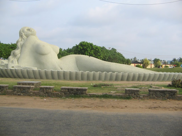
                                                Mermaid Statue in Shanmugham Beach